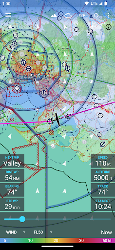
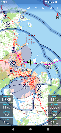
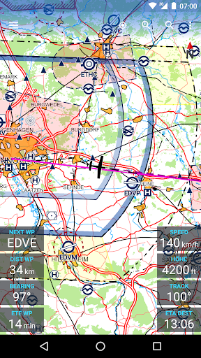
NEW: You can now set a target descent altitude (e.g. traffic pattern altitude) for the destination airport.
NEW: Lock the map at your location by pressing the lock icon below the compass. After manually panning the map, it will then move back and keep following your location.
NEW: Added setting to disable map rotation.
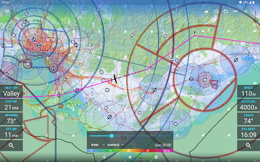
NEW: Added display of the map scale.
Change: Added button to the waypoint dialog to add waypoint at the end of the route as destination (like previously).
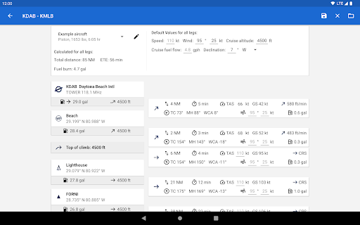
Change: Setting the initial climb altitude at the first airport and setting the cruise altitude of the route are now synonymous.
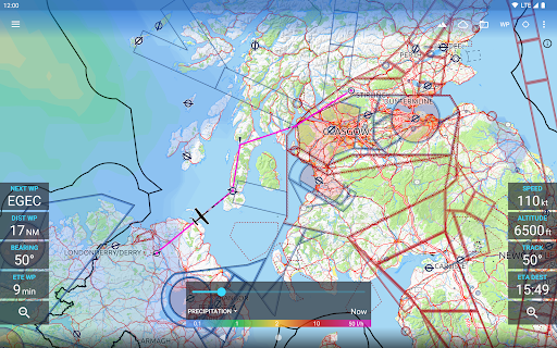
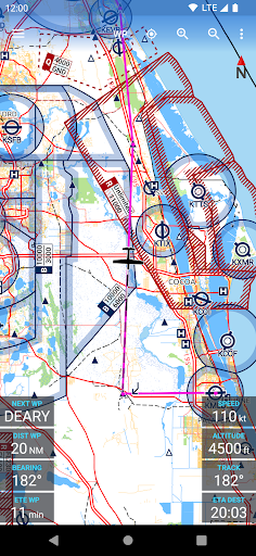
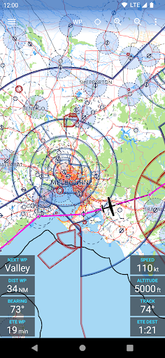
Change: The route is now displayed on the map using great circle segments.
Bugfix: On the advanced route planning screen, the unit of the cruise altitude was always "ft" (even if "m" were selected as unit).
Bugfix: Tiles without any aviation data (e.g. in the middle of the ocean) could not be removed from the device.
Minor bugfixes and performance improvements.
Bugfix: Airspaces were not drawn on Android 7 and older.
Minor bugfixes and compatibility with Android 14.
Change: Updated French translation.
Bugfix and Performance: Changes in the map engine to reduce memory pressure and avoid OOM errors.
Minor bugfixes and compatibility with Android 14.
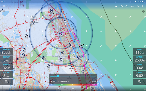
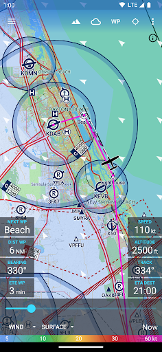
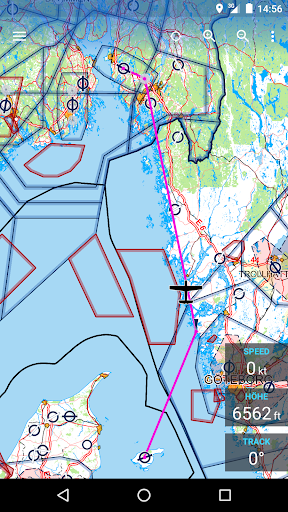
NEW: Traffic overlay. The app can now receive and display GDL90 traffic data from Safe Sky and compatible ADS-B receivers.
Change: Updated Czech translation.
Bugfix: Handle aircraft models without mass variation between climb rate fulcrums.
NEW: Traffic overlay. The app can now receive and display GDL90 traffic data from Safe Sky and compatible ADS-B receivers.
Change: Updated Czech translation.
Bugfix: Handle aircraft models without mass variation between climb rate fulcrums.
NEW: Traffic overlay. The app can now receive and display GDL90 traffic data from Safe Sky and compatible ADS-B receivers.
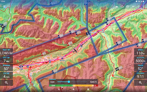
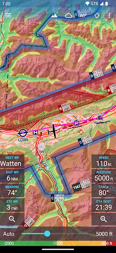
NEW: Colored terrain overlay depending on your current or manually selected altitude. After the download the app will first have to prepare the overlay once, which is a long running task. Available on Android 7+.
Change: The zoom buttons are now larger and moved from the toolbar to the bottom of the screen.
Change: Previously the .gpx route import was limited to 100 waypoints. Now tracks with more points can also be imported but are smoothed.
Several minor bugfixes.
Bugfix: Fixed error which crashed the app when starting downloads in case the permission to show a download progress notification was never granted.
Minor bugfixes.
Change: Support for new AIP download format.
Minor bugfixes.
NEW: Added "Avia Maps Professional" subscription as alternative purchase option to unlock the app and all add-on features, i.e. weather forecasts directly on the map and sync, at once.
Several minor bugfixes.
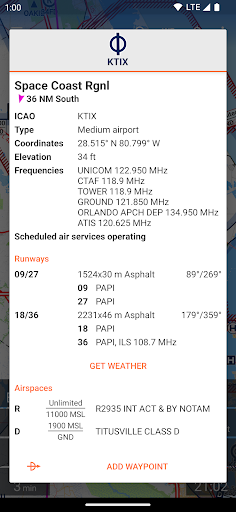
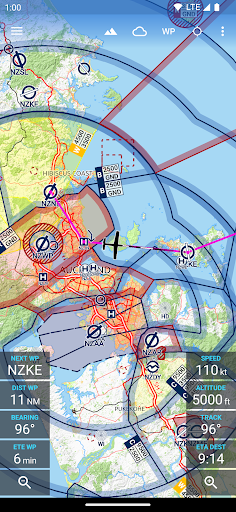
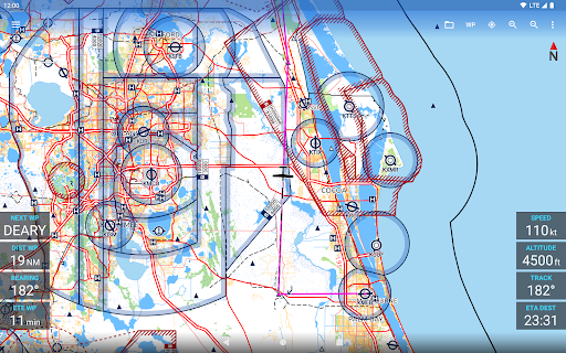
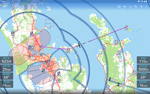
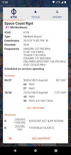
NEW: Display of FIR frequencies directly on the map.
NEW: Support for Nature Reserve Area and ADIZ airspaces.
Change: Improved rendering of airspaces.
Change: Automatic activation of navigation mode can be configured based on location or speed - not both.
Bugfix: Fixed the delayed download of weather forecasts when the app was running in the background.
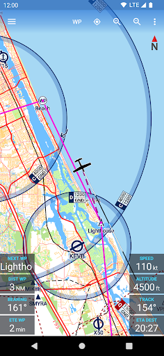
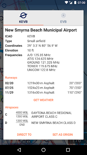
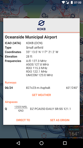
NEW: Navaid idents and names of smaller airports are now drawn on the map.
Bugfix: Fixed a bug which may have caused the app to crash when attempting to automatically resolve a sync conflict.
Bugfix: Crash caused by invalid characters in user waypoint names.
Minor bugfixes.
NEW: Synchronization for routes, aircraft models and user waypoints
NEW: Additional icons for user waypoints (obstacle and warning)
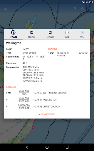
NEW: Button in the waypoint dialog to report data errors (outside the USA only, as US waypoint data is taken directly from the FAA)
Change: Increased touchable area for route waypoints on lower zoom levels.
NEW: Synchronization for routes, aircraft models and user waypoints.
NEW: Import user waypoint names from GPX and FPL files.
NEW: Support for Android 12
Bugfix: Fixed a bug where waypoint names would not disappear when closing a route.
Bugfix: Incorrect GPX route import.
Completely reworked route storage to integrate sync and fixed several minor bugs in the process.
Improved map rendering performance.
Bugfix: Missing map overlay update when editing user waypoints which are not saved to database.
Fixed some bugs which could cause the app to crash in rare circumstances (less than 1% of users were affected).
NEW: Now drawing the names of user waypoints on the map (on higher zoom levels only).
NEW: Delete user waypoint via delete button in main waypoint dialog if it is not part of the current route (no need to first open the edit user waypoint dialog).
Change: User waypoints are now also visible on lower zoom levels.
Bugfix: Fixed missing "route has been changed" when moving a waypoint via drag-and-drop in the map.
Minor bugfixes.
Version 3.1:
NEW: User waypoints. Rename and save custom waypoints to permanently display them on the map and to use them in multiple routes.
Version 3.0:
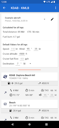
NEW: Aircraft Models to save multiple sets of default values for route planning. Including an option for unpowered aircraft.
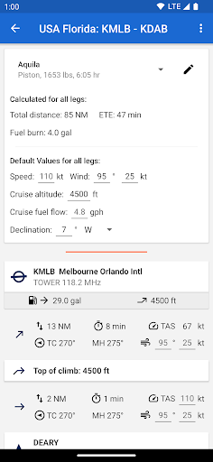
NEW: Climb & Descent calculations. Depending on the performance of your A/C model, top of climb and top of descent will be calculated and drawn on the map.
NEW: Different icons for mandatory and optional VFR reporting points
Change: Now using vector drawables throughout the app to better support high DPI devices
Change: Fixed some typos in Spanish and Czech translations
Bugfix: Fixed potential crash when moving the first waypoint within the map
Change: Improved Czech translation
Bugfix: Prevent duplicate waypoints when using in-map route editing
Change: Improved Czech translation
Bugfix: Prevent duplicate waypoints when using in-map route editing
NEW: Instant display of search results when searching by keyword in waypoint search dialog.
NEW: Czech translation.
Change: Updated Spanish translation.
Bugfix: Fixed an issue with the drag-and-drop editing of previously saved routes.
Minor bugfixes.
Bugfix: In-app AIP update issue fixed.
NEW: Download status dialog which allows to cancel the downloads and to toggle the "download via WiFi only" flag.
Change: Improved downloads notification.
Change: Improved downloads routine with seamless failover between different server backends.
Some minor bugfixes.
NEW: Import and export routes.
NEW: Organize saved routes in folders.
NEW: Dialog to manage saved routes.
Bugfix: Hiding traffic pattern altitude text views from direct-to origin dialog.
Bugfix: Main toolbar item to open route management dialog works again (tablets only).
Bugfix: Missing GPS heading when moving restored.
Many minor performance improvements, memory optimizations and bug fixes.
NEW: Import and export routes.
NEW: Organize saved routes in folders.
NEW: Dialog to manage saved routes.
Change: Reduced lower limit to filter airspaces by altitude from 5000ft to 1000ft.
Many minor performance improvements, memory optimizations and bug fixes.
NEW: Import and export routes.
NEW: Organize saved routes in folders.
NEW: Dialog to manage saved routes.
Change: Reduced lower limit to filter airspaces by altitude from 5000ft to 1000ft.
Many minor performance improvements, memory optimizations and bug fixes.
NEW: Choose between aircraft, balloon or helicopter icon for own-ship position.
Change: Improved wording of Frensh translation.
Bugfix: Fixed out of memory error when viewing map close to 180 degrees East or West.
Minor bugfixes.
NEW: Setting to hide dashed line to next waypoint
NEW: French and Spanish translations
Change: Increase flight path projection length to up to 60 minutes (via settings menu).
Change: Showing route name in title of waypoint drawer and advanced route planning.
Change: Improved IPv6 backend support
Minor bugfixes.
NEW: Setting to hide dashed line to next waypoint
NEW: French and Spanish translations
Change: Showing route name in title of waypoint drawer and advanced route planning.
Change: Improved IPv6 backend support
Minor bugfixes.
NEW: Drag-and-drop route editing within the map. Simply long press the route or a waypoint to edit.
NEW: Traffic Patterns. Data currently available for Germany only. Will be activated with the next in-app AIP update.
NEW: Show distance and bearing to waypoint in dialogs
NEW: Transparent navigation bar on tablets
Change: Improved layout of waypoint dialogs on tablets
Change: Major overhaul of AIP handling for better performance and lower memory usage
Minor bugfixes.
Change: Improved in-app billing implementation now supports pending transactions. Issues related to multiple Google Accounts on a single device will be fixed with a future update.
Minor bugfixes.
Change/Bugfix: The app now uses a custom download manager instead of the system service to avoid problems when downloading directly to an SD card. This also improves the UI because there will always be a meaningful notification while downloading (on some devices the system service does not display a notification).
Change: The load-route-dialog now sorts the routes alphabetically (previously by creation date).
Minor bugfixes.
NEW: Temporarily hide the A/C symbol from the map (e.g. during flight training).
NEW: Waypoint keyword search now supports coordinates and national IDs of airports.
NEW: Specific airspace style for Flight Information Regions (FIR).
NEW: Setting to specify the speed threshold to switch from magnetic heading to GPS track.
Bugfix: Crash at high zoom levels, active navigation and very large distance to next waypoint fixed.
Bugfix: Made maps download routine more reliable.
Minor bugfixes.
NEW: Link to our new knowledge base in the info section. Will be expanded over time.
Change: New modern icon.
Change: Moved feedback button from main screen to info screen.
Minor bugfixes.
Bugfix: Airspace labels were drawn solid on some devices. Now the height limits should always be on a white transparent background.
Minor Bugfixes.
NEW: Airspace labels with height limits will be drawn directly on the map (BETA). Labels become visible when zooming in. Will be enabled with the upcoming in-app AIP update.
NEW: GNSS status page.
Change: Geoid correction can be disabled via the altitude offset dialog - because some receivers seem to provide unreliable data.
Bugfixes and performance improvements of the map engine.
NEW: Now applying WGS84 to Geoid correction to altitude.
NEW: Progress dialog when verifying map files after download.
NEW: Progress dialog when moving maps to SD card (supported on Android 6+ via in-app map manager).
NEW: Display date of trial registration in info dialogs during 30-day evaluation period.
Change: Limited length of VRP idents printed on map (affects primarily South African VRPs, available with the in-app AIP update scheduled for Jan 16th).
Bugfixes.
NEW: Auto hide certain waypoints when zooming out to keep the map readable. Can be configured or disabled in the settings.
NEW: Choose your favorite format for coordinates in the settings.
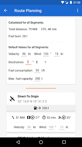
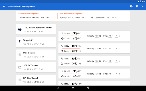
NEW: The route overview (left drawer on the main map screen) now includes the time of each leg.
Change: Ask for confirmation before activating direct-to when a route is already active.
Bugfix: Wording.
Change: When reaching the destination the navigation will now only end automatically after the speed drops below 30 kts.
Bugfix: Improved GNSS/INS speed and heading availability in flight.
Bugfix: Fixed missing (not drawn) map tiles when in flight.
Bugfix: Improved overall map response / performance when in flight.
Bugfix: Fixed incorrect map fling and zoom animations when the map was rotated.
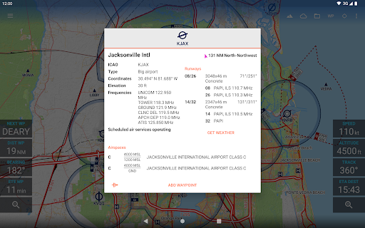
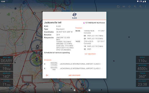
NEW: Closed (but still existing) runways are now shown and marked as such in the airport dialog.
Bugfix: At some airports the runway data has not been displayed in the dialog although it was used to draw the icon on the map.
Bugfix: Bug which causes some devices to crash when starting Direct-To navigation should be fixed now.
Bugfix: Added button in the info dialog of the map manager to re-download all aviation data in case it was not downloaded correctly.
NEW: Support of additional zoom levels.
Bugfix: Fixed bug which caused the app to crash on some devices when activating direct-to navigation.
Bugfix: Fixed bug which caused the app to crash when moving map data to an external SD-card and that SD-card was removed after starting the app.
Bugfix: Reduced memory usage to avoid out-of-memory errors on lower spec devices.
Minor bugfixes.
NEW: Support of additional zoom levels. These will be made available via an in-app update once this app update is available to all users and must then be enabled using the "map manager".
Change: Overhaul of the download and download verification routines of base map updates in preparation of the upcoming release of the additional zoom levels and updated base maps.
Minor bugfixes.
Change: Major overhaul of the download and download verification routines in preparation of the upcoming release of additional zoom levels and updated base maps.
Minor bugfixes.
Change: To comply with the EU GDPR, the app now requires the user to accept the privacy policy on first launch of the app.